How to Prepare for a Drone Roof Survey: A Complete Guide
Drone roof surveys offer commercial property owners and investors a fast, safe way to assess building condition — but proper preparation makes all the difference. This guide walks through every step, from defining survey objectives and notifying stakeholders to managing site access and reviewing findings.
For commercial property owners and investors, maintaining a clear understanding of a building's condition is essential. Whether you're managing a single asset, overseeing a portfolio, preparing for a transaction, or planning maintenance works, the condition of a property's roof can significantly influence costs, operational risks, and long-term value.
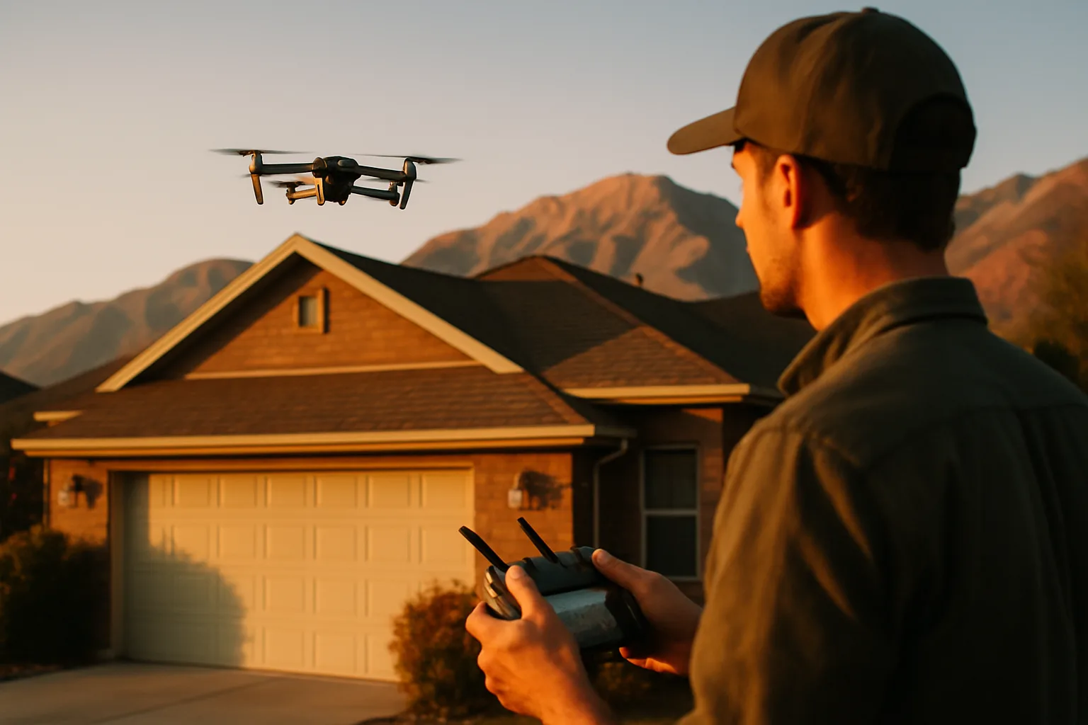
Drone roof surveys have become an increasingly popular solution for assessing roof conditions quickly, safely, and accurately. By using advanced aerial technology, surveyors can capture detailed imagery and data without the need for extensive access equipment, reducing disruption while providing valuable insights.
However, to achieve the best possible results, preparation is important. A well-prepared site allows surveyors to work efficiently, collect high-quality data, and deliver more accurate findings.
This guide explains how commercial property owners and investors can prepare for a drone roof survey and ensure the process runs smoothly from start to finish.
Understanding the Purpose of a Drone Roof Survey
Before making preparations, it is helpful to understand what a drone roof survey is designed to achieve.
A drone roof survey uses unmanned aerial vehicles (UAVs) equipped with high-resolution cameras and, in some cases, thermal imaging technology to inspect roofs and elevated building elements. The survey can identify issues such as:
Damaged or missing roof coverings
Ponding water and drainage problems
Deterioration of roof membranes
Defective flashing and detailing
Cracks and structural concerns
Vegetation growth
Signs of water ingress
General wear and ageing
For investors, drone surveys can support due diligence during acquisitions or asset reviews. For property owners and facilities managers, they provide valuable information for maintenance planning, budgeting, and risk management.
Clarify the Objectives of the Survey
One of the most important preparation steps is defining exactly what you want the survey to achieve.
Different surveys may focus on different objectives. For example:
Assessing the general condition of a roof
Investigating a suspected leak
Supporting planned refurbishment works
Documenting insurance-related damage
Conducting pre-acquisition due diligence
Monitoring the condition of assets over time
Providing clear objectives allows the surveyor to tailor the inspection accordingly. It can also help determine whether additional data collection methods, such as thermal imaging, should be included.
The more information you provide at the outset, the more targeted and valuable the final report is likely to be.
Share Relevant Property Information
Surveyors can work more effectively when they understand the property before arriving on site.
Consider providing:
Building addresses and site plans
Roof layout drawings
Previous inspection reports
Maintenance records
Information about known defects
Details of recent repairs or alterations
Access restrictions
Operational requirements
If you have existing documentation, sharing it in advance can help surveyors identify areas requiring particular attention.
For larger commercial sites, information about multiple roof sections, plant equipment, or restricted zones can be especially useful.
Notify Occupants and Stakeholders
Although drone roof surveys are generally less disruptive than traditional inspection methods, it is still advisable to inform relevant stakeholders beforehand.
This may include:
Building occupants
Facilities management teams
Security personnel
Tenants
Site managers
Contractors working on site
Providing advance notice helps prevent confusion on the day of the survey and ensures everyone understands why drone operations are taking place.
For multi-tenant properties, clear communication can also help address any questions regarding privacy and site activity.
Ensure Access to the Site
While drones reduce the need for physical roof access, surveyors still require safe access to the property and surrounding areas.
Before the survey, confirm that:
Site entrances are accessible
Gates can be opened if required
Security teams are informed
Parking arrangements are available
Restricted areas can be accessed when necessary
The survey team may also need access to specific locations for equipment setup, take-off, and landing.
In some cases, surveyors may request access to internal areas if they need to investigate signs of water ingress or compare roof findings with internal conditions.
Identify Potential Site Hazards
Commercial properties often contain features that can affect drone operations.
Before the survey takes place, identify any potential hazards such as:
Overhead power lines
Telecommunications equipment
Construction activities
Tall structures
Cranes
High vehicle traffic areas
Sensitive operational zones
Providing this information in advance helps surveyors develop appropriate flight plans and risk assessments.
A professional drone operator will carry out their own safety checks, but advance knowledge of site-specific risks contributes to a more efficient survey process.
Review Airspace Considerations
Not every property is located in unrestricted airspace.
Buildings situated near airports, military facilities, transport hubs, or other controlled areas may require additional permissions before drone operations can proceed.
Experienced survey providers will usually manage these requirements, but it is helpful to make them aware of any known restrictions during the planning stage.
Allowing sufficient time for approvals can prevent delays and ensure the survey takes place as scheduled.
Consider the Timing of the Survey
Weather conditions play a significant role in drone operations.
High winds, heavy rain, fog, and poor visibility can affect flight safety and image quality. As a result, survey dates may occasionally need to be adjusted to accommodate suitable weather conditions.
When scheduling a survey, consider:
Seasonal weather patterns
Operational requirements
Occupancy levels
Planned maintenance activities
Construction works on site
Flexibility can help ensure the survey captures the highest quality data possible.
For investors working to acquisition deadlines or property owners coordinating maintenance programmes, building some contingency into project schedules is often beneficial.
Prepare Roof and Surrounding Areas
While surveyors do not usually require direct access to the roof itself, ensuring surrounding areas are reasonably clear can improve survey efficiency.
Where practical:
Remove temporary obstructions
Relocate vehicles if requested
Secure loose materials
Inform contractors of survey activities
Minimise unnecessary movement in operational zones
A tidy site allows surveyors to capture clearer imagery and reduces the risk of avoidable disruptions during flights.
Understand What Data Will Be Collected
Before the survey begins, discuss deliverables with your chosen provider.
Depending on the scope of work, outputs may include:
High-resolution photographs
Detailed inspection reports
Annotated defect images
Orthomosaic roof maps
Thermal imaging data
3D roof models
Maintenance recommendations
Understanding what information will be provided helps ensure the survey meets your objectives and supports future decision-making.
For portfolio owners and investors, consistency in reporting can be particularly valuable when comparing multiple assets. If you're also evaluating long-term property performance, our guide on how to measure long-term real estate appreciation covers useful metrics for benchmarking asset condition against value trends.
Verify Regulatory Compliance
Drone operations in the UK are subject to regulatory requirements.
When selecting a survey provider, ensure they have appropriate qualifications, permissions, and insurance coverage. Professional operators should be able to demonstrate compliance with relevant aviation regulations and industry best practices.
Working with a reputable provider helps protect both the property owner and the survey team while ensuring the data collected is reliable and legally obtained.
This is especially important for commercial assets where survey findings may influence investment decisions, maintenance budgets, or legal documentation.
Coordinate with Other Property Assessments
A drone roof survey often forms part of a wider property evaluation process.
For example, investors conducting due diligence may combine roof inspections with structural assessments, condition surveys, or a measured building survey to gain a comprehensive understanding of an asset.
Similarly, property owners planning refurbishment works may use drone findings alongside other specialist reports to prioritise repairs and allocate budgets effectively. Understanding which home improvements boost property value can help owners prioritise the most impactful repairs after a survey.
Coordinating multiple assessments can improve efficiency and provide a more complete picture of the property's condition.
Be Ready to Review the Findings
Preparation should not end once the survey has been completed.
After receiving the report, take time to review the findings carefully and discuss any concerns with the surveyor.
Consider:
The severity of identified defects
Recommended remedial actions
Estimated maintenance priorities
Potential operational risks
Long-term capital expenditure implications
For investors, the survey may reveal factors that influence negotiations, acquisition decisions, or future investment planning.
For owners, it provides a valuable opportunity to address issues before they develop into more significant and costly problems.
The Benefits of Proper Preparation
A drone roof survey can provide substantial value, but the quality of the outcome often depends on the level of preparation beforehand.
By defining objectives, sharing relevant information, coordinating site access, and ensuring stakeholders are informed, commercial property owners and investors can help surveyors gather the most accurate and useful data possible.
Compared with traditional inspection methods that may require extensive access equipment and involve greater risks associated with working at heights, drone surveys offer a safer, faster, and often more cost-effective alternative.
When properly planned and executed, a drone roof survey delivers clear insights into asset condition, supports informed decision-making, and helps protect the long-term value of commercial property investments.
As technology continues to evolve, drone surveys are becoming an increasingly important tool within modern property management and investment strategies. Taking the time to prepare effectively ensures you gain the maximum benefit from the survey and the information it provides.
Frequently asked questions
What can a drone roof survey detect on a commercial property?
Do I need to clear the roof before a drone survey takes place?
How does weather affect drone roof survey scheduling?
What permissions are needed for drone operations near airports or restricted airspace?
What deliverables should I expect from a drone roof survey report?
Keep reading
More from the blog
How to Choose a Garage Door for Utah's Climate
Why Reliable Handyman Services Add Value to Rental Properties
Are Home Standby Generators Worth It? A Homeowner's Guide