
Discover Provo Utah: Your Guide to Hidden Gems and Scenic Spots
Scenic and lesser-known spots in Provo, Utah: Kyhv Peak Overlook, Stewart Falls, Rock Canyon, the Provo River Parkway, free BYU museums and more.
Provo is best known for BYU, but the city of about 115,000 people (115,162 at the 2020 census) also sits between the Wasatch Range and the east shore of Utah Lake, which puts canyons, waterfalls, overlooks, and a long river trail within a 20-minute drive of downtown. Many of the best spots are free, and several are places visitors drive past without knowing they're there.
This guide focuses on the scenic spots and lesser-known stops that locals use: an overlook most visitors never find, a waterfall hike above Sundance, a 15-mile paved river trail, a historic library, free museums, and the downtown events worth timing a trip around. For the headline attractions, the companion list of the top 10 things to do in Provo covers the big names. Anyone thinking about staying longer can browse Provo homes for sale.
Kyhv Peak Overlook: The View Most Visitors Miss
The Kyhv Peak Overlook (formerly called Squaw Peak Overlook; the peak was officially renamed in 2022) is reached by a paved, winding road that branches off Provo Canyon about two miles from the canyon mouth. At the top, the view takes in all of Utah Valley: Utah Lake and the cities along its shore to the west, and the Wasatch peaks to the north and east. It's a favorite sunset spot.
The road is seasonal and typically closed from about November 1 to May 1, depending on snow. Hikers can also reach the peak itself on a strenuous trail that starts at the Rock Canyon trailhead.
Stewart Falls
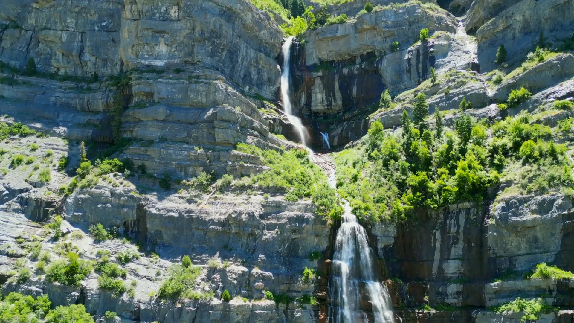
Stewart Falls is a two-tiered waterfall on the east flank of Mount Timpanogos, above Sundance Mountain Resort. The standard hike starts at the Aspen Grove trailhead on the Alpine Loop and runs about 3.5 miles round trip, with moderate ups and downs through aspen forest. A second route climbs to the falls from Sundance itself.
- Best season: late spring through fall, when the Alpine Loop road is open; the falls run strongest in early summer as snow melts
- Fees: a recreation fee is collected at the Alpine Loop toll booth
- Tip: the trailhead lot fills early on summer weekends, so arrive in the morning
Bridal Veil Falls and the Provo River Parkway
Bridal Veil Falls is the most famous waterfall in Provo Canyon and the easiest to see — it's visible from US-189 and a short walk from the parking area. The falls are usually cited at about 600 feet, dropping in several tiers down the canyon wall. It is worth a stop in every season, including winter, when the falls freeze.
The Provo River Parkway connects it all. This paved trail runs about 15 miles from Utah Lake State Park, through Provo, and up Provo Canyon to Vivian Park, with parks, restrooms, and picnic areas along the way. Walking, running, biking, and rollerblading are all common, and the canyon section stays shaded and cool along the river. Short sections close periodically for construction, so check Provo Parks for detours.
Rock Canyon
Rock Canyon opens directly above Provo's northeast bench, and Rock Canyon Park at its mouth is the trailhead. The trail follows the canyon floor between steep rock walls that are popular with climbers. Hikers can go as far as they like: a short walk in for the canyon views, or a long day toward the upper canyon.
Northeast-bench neighborhoods such as Indian Hills, just below Rock Canyon, and Sherywood Hills, a little farther north toward Provo Canyon, are among the closest in Provo to major trailheads.

The Y Mountain Trail
The block "Y" on the mountainside above BYU has marked the city since the early 1900s, and the trail to it is a Provo rite of passage. It's short but steep, with a long series of switchbacks. The reward is a view over campus, the city grid, and Utah Lake. Go early in the morning or near sunset in summer; there is little shade.
Utah Lake State Park at Sunset
Utah Lake is the largest natural freshwater lake in Utah, and Provo sits on its east shore. Utah Lake State Park, at the west end of Center Street, has boat ramps, a marina, picnic areas, and campsites, and it marks the start of the Provo River Parkway. Paddleboarding, kayaking, fishing, and bird watching are all common. Evening is the time to go, when the sun drops behind the mountains on the far side of the lake.

The Provo City Library at Academy Square
The Provo City Library is one of the most striking public buildings in the state. It occupies the restored Brigham Young Academy building on University Avenue, dedicated in 1892 as the academy's first building. After BYU left its lower campus, the building sat empty for years before a bond and private fundraising paid for its restoration; it reopened as the city library in 2001. Visitors can walk the halls, see the historic architecture, and use it as a quiet stop between downtown and campus.
BYU's Free Museums
Brigham Young University's campus museums are free to visit, which makes them some of the best-value stops in town:
- Monte L. Bean Life Science Museum — animal and natural-history exhibits, plus live-animal programs; free admission, open Monday through Saturday
- BYU Museum of Art — rotating exhibitions and a permanent collection that ranges from traditional to contemporary work
- BYU Museum of Paleontology — dinosaur skeletons and fossils
Sports fans can also catch a BYU game: football at LaVell Edwards Stadium and basketball at the Marriott Center are the big draws, while volleyball and soccer matches are easier tickets.

Downtown Provo
Downtown Provo centers on Center Street and University Avenue, with restored historic buildings, independent restaurants, coffee shops, and galleries. Two downtown anchors are worth knowing:
- Covey Center for the Arts (425 W Center St) — the city's performing arts center, with a 670-seat main hall, a black box theater, and two art galleries
- Provo Farmers Market — held Saturdays at Pioneer Park (500 W Center St) from June through October, with a winter market indoors at Provo Towne Centre
Provo's free Rooftop Concert Series ran on first Fridays each summer from 2010 to 2019, and the city announced in early 2026 that the series would return. Check current schedules before planning around it.

Summer in Provo: Water Parks and the Freedom Festival
Splash Summit Waterpark is Provo's summer water park, with slides, a lazy river, and areas for younger children. It's a seasonal operation, so check opening dates each year.
America's Freedom Festival takes over Provo every July. The festivities include a large Fourth of July parade and the Stadium of Fire at LaVell Edwards Stadium, a concert and fireworks show billed as the largest stadium fireworks show in the country for Independence Day. Tickets typically go on sale in spring, and the parade route fills early on the morning of the Fourth.

Free Things to Do in Provo
- Drive to the Kyhv Peak Overlook for sunset (seasonal road)
- Hike Rock Canyon or the Y Mountain trail
- Walk or bike any stretch of the Provo River Parkway
- See Bridal Veil Falls from the parking area in Provo Canyon
- Visit the Monte L. Bean Life Science Museum and other BYU museums
- Tour the Provo City Library at Academy Square
- Browse the Saturday farmers market at Pioneer Park
A Half-Day Scenic Loop
- Morning: Hike Stewart Falls from Aspen Grove before the lot fills, then drive back down past Sundance.
- Midday: Stop at Bridal Veil Falls in Provo Canyon and walk a stretch of the Provo River Parkway.
- Afternoon: Visit the Monte L. Bean museum or the Provo City Library, then grab food downtown.
- Sunset: Drive up to the Kyhv Peak Overlook (May through October) or head west to Utah Lake State Park.
Seasonal Tips
Summer is peak season for canyon hikes, the lake, and the Freedom Festival, but July afternoons are hot on exposed trails like the Y. Fall is the most comfortable time for hiking, with color in Provo Canyon and on the Alpine Loop from late September into October. The Alpine Loop road and the Kyhv Peak road close in winter, while Sundance turns into a ski resort. Spring snowmelt makes the waterfalls run hardest. For month-by-month temperatures, see the guide to Provo weather.
Living Near Provo's Best Spots
For anyone weighing a move, current Provo market numbers are:
- Median sale price: $484,100
- Median days on market: 41 days
- Active listings: 267
The east bench below Rock Canyon puts trailheads close at hand, Grandview in north Provo sits close to the Provo River Parkway, and Provo homes with views look out over the valley and lake. Buyers who want a lower-maintenance place near campus and downtown can start with Provo condos for sale. The pros and cons of living in Provo guide covers the trade-offs in more depth.
Bottom Line
Provo's best scenic spots are close and mostly free: an overlook above the canyon, two waterfalls, a 15-mile river trail, a canyon walk minutes from the east bench, and a sunset over Utah Lake. Add a stop at the Academy Square library, a free BYU museum, and a Saturday at the farmers market, and a weekend fills up quickly. For more ideas, the broader moving to Utah guide covers the rest of the state.
Posted by Kristopher Larson
Frequently asked questions
What are some fun things to do in Provo, Utah?
Popular choices include hiking Stewart Falls, Rock Canyon, or the Y Mountain trail; seeing Bridal Veil Falls in Provo Canyon; biking the 15-mile Provo River Parkway; watching the sunset from the Kyhv Peak Overlook or Utah Lake State Park; visiting BYU's museums; catching a BYU game; and, in summer, Splash Summit Waterpark and the Freedom Festival's Stadium of Fire.
What are the best free things to do in Provo?
Many of Provo's best stops are free: the Kyhv Peak Overlook, Rock Canyon and Y Mountain trails, the Provo River Parkway, the Bridal Veil Falls viewing area, the Monte L. Bean Life Science Museum and other BYU museums, the Provo City Library at Academy Square, and the Saturday farmers market at Pioneer Park. Some canyon trailheads, such as Aspen Grove for Stewart Falls, require a recreation fee.
Where is the best viewpoint in Provo?
The Kyhv Peak Overlook, formerly called Squaw Peak Overlook, has the widest view of Utah Valley and Utah Lake. It's reached by a paved road off Provo Canyon about two miles from the canyon mouth. The road is typically closed from about November 1 to May 1. The Y Mountain trail is a closer alternative with a view over BYU and the city.
How long is the Stewart Falls hike?
The standard route from the Aspen Grove trailhead on the Alpine Loop is about 3.5 miles round trip with moderate ups and downs. A second route reaches the falls from Sundance Mountain Resort. The hike is best from late spring through fall while the Alpine Loop road is open.
What is Provo, Utah known for?
Provo is known as the home of Brigham Young University, for its location between the Wasatch Range and Utah Lake, and for outdoor access through Provo Canyon, Rock Canyon, and the Y Mountain trail. It also hosts America's Freedom Festival each July, including the Stadium of Fire at LaVell Edwards Stadium. The city had 115,162 residents at the 2020 census.
What is the best time of year to visit Provo?
Late spring through fall is the easiest window. Early summer brings the strongest waterfalls, July brings the Freedom Festival, and September and October bring cooler hiking weather and fall color in Provo Canyon and on the Alpine Loop. In winter, the Alpine Loop and Kyhv Peak roads close, but Sundance becomes a ski resort and the downtown and BYU museums stay open.
Provo, Utah housing market
A quick read on what homes are doing in Provo right now — pulled live from the MLS.
Keep reading
More from the blog
Provo, Utah: Unexpected Local Rules, Customs & Real Estate Tips
Moving to Provo, Utah in 2025 — Neighborhoods, Housing & Schools
What's the Weather Like in Provo, Utah?
